

As technology advances, NOAA continuously looks for ways to augment the capabilities of its fleet and other traditional data-gathering tools to meet NOAA mission needs. The NOAA Uncrewed Systems Operations Center is currently supporting multiple projects to explore how uncrewed systems can provide novel methods of data collection and enhance NOAA’s existing data-gathering tools. In celebration of the inaugural NOAA Fleet Week, here are five examples of projects the Uncrewed Systems Operations Center is supporting that are using uncrewed systems to forge new pathways in ocean and atmospheric data collection and processing.
Uncrewed surface vehicles to operate in place of moored ocean buoys
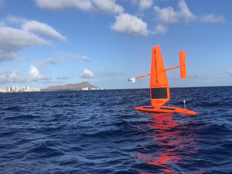
Moored data buoys are a tool traditionally maintained by the NOAA National Data Buoy Center (NDBC) that collects information on the weather and ocean conditions. In 2023, the NDBC entered a public-private partnership with Saildrone, Inc. to deploy and operate an uncrewed surface vehicle to replace a moored data buoy in Monterey Bay National Marine Sanctuary.
Unlike a moored data buoy, uncrewed surface vehicles are not tethered to the seafloor, thus reducing seafloor disturbance and can be deployed from land without the use of a crewed ship. NDBC is also exploring the use of uncrewed surface vehicles as on-call platforms to replace data buoys with transmission outages. The implementation of uncrewed systems to collect ocean data can improve in-situ observations and improve real-time reporting of ocean and atmospheric observations.
Uncrewed systems to inform hurricane research

NOAA scientists can use uncrewed systems to improve hurricane data gathering by collecting previously unattainable data from the area of the storm just above the ocean’s surface, called the Boundary Layer. The NOAA Atlantic Oceanographic and Meteorological Laboratory, along with its government, academic, and industry partners, uses data gathered from uncrewed surface vehicles, underwater buoyancy gliders, and uncrewed aircraft systems to advance the agency’s understanding of hurricane intensification.
Since 2014, NOAA and its partners have deployed a fleet of underwater buoyancy gliders to improve the understanding of the role of the ocean in hurricane intensification. Throughout the same time period, NOAA scientists have been exploring the use of small uncrewed aircraft systems in improving hurricane forecasts.
During the 2022 and 2023 hurricane seasons, NOAA personnel were able to deploy four small uncrewed aircraft systems (two Black Swift S0; two Altius 600) from the NOAA Hurricane Hunter planes into Hurricane Tammy. These systems can gather data from areas too dangerous for crewed aircraft to access. Additionally, NOAA has partnered with Saildrone Inc. to deploy uncrewed surface vehicles that gather data at the air-sea interface in the path of hurricanes.
During recent hurricane seasons, NOAA has worked to perform collocated missions of these uncrewed systems. NOAA personnel are exploring the use of uncrewed systems-gathered data to gain a holistic understanding of the ocean-atmosphere dynamics that drive hurricane intensification and to better inform hurricane forecasts to protect lives and property.
Uncrewed marine systems to survey the seafloor

NOAA researchers are working to utilize uncrewed marine systems as a means to increase the ease and safety of seafloor surveys. For example, the Pacific Islands Fisheries Science Center is testing a toaster oven-sized micro-autonomous underwater vehicle, the Advanced Navigation Hydrus, as a tool to conduct benthic surveys of coral reef habitat.
The use of the Hydrus can increase safety by alleviating the need for diver-collected imagery and can reduce the need for extensive ship time making benthic imaging more attainable for smaller, more remote research teams. Once operational the imaging data collected by the Hydrus will be used to supplement the National Coral Reef Monitoring Program.
Uncrewed systems to operate collaboratively

In fall of 2024, the NOAA Ocean Exploration Cooperative Institute will participate in multi-vehicle uncrewed systems operations in American Samoa as a part of NOAA Ocean Exploration’s Beyond the Blue Campaign. During back-to-back cruises on Ocean Exploration Trust’s E/V Nautilus, operations will include remotely operated vehicle Hercules, the University of New Hampshire’s uncrewed surface vehicle DriX, the University of Rhode Island’s Deep Autonomous Profiler, and Woods Hole Oceanographic Institution’s Sentry autonomous underwater vehicle and midwater hybrid vehicle, Mesobot.
The operations will survey the seafloor and water column as well as evaluate volcanic environments of American Samoa, including within the Rose Atoll Marine National Monument. Simultaneous multi-vehicle operations can leverage vehicle strengths for targeted observations along with intra-vehicle communication and cooperation to achieve more efficient, synoptic ocean observations and these efforts will improve the NOAA fleet’s capability to conduct such operations in the future.